
London
This is our current list of London Maps stocked in our gallery. Please use the Enquire Now button to ask a question or order and we will be back to you as soon as possible.
Showing all 10 results
-
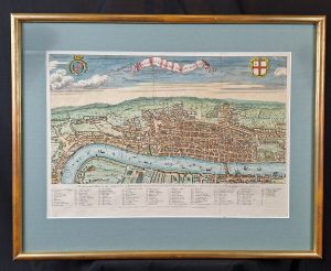
A View of London about the Year 1560
Medium: Copper EngravingEngraver: George VirtueDated: 1738Image Dimensions: 23¾" x 18½" (60.33cm x 46.99cm) -
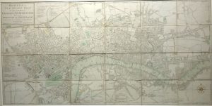
Bowles’s New Pocket Plan of the Cities of London and Westminster with the Borough of Southwark
Dated: 1785Image Dimensions: 36" x 18" (91.4cm x 45.7cm) -
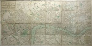
Bowles’s New Pocket Plan of the Cities of London and Westminster with the Borough of Southwark
Dated: 1788Image Dimensions: 36¼" x 18¼" (92.1cm x 46.4cm) -

Langborne Ward
Dated: c. 1720Image Dimensions: 14¾" x 12" (37.5cm x 30.5cm) -
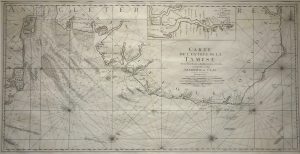
Map of the Thames Estuary, Carte de L’entrée de la Tamise
Dated: 1693Image Dimensions: 35½" x 18¼" (90.2cm x 46.4cm) -

Plan of Aldersgate, Bishopsgate, Bread Street & Cordwainers Wards
Dated: 1784Image Dimensions: 8¾" x 13½" (22.2cm x 34.3cm) -
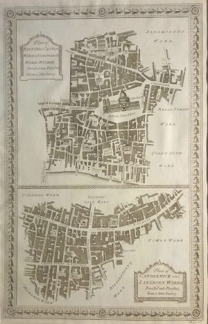
Plan of Baynards Castle, Farringdon, Candlewick & Langborn Wards
Dated: 1784Image Dimensions: 8½" x 13¼" (21.6cm x 33.7cm) -
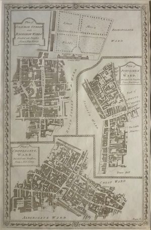
Plan of Coleman Street, Bassishaw, Portsoken & Cripplegate Wards
Dated: 1784Image Dimensions: 8¾" x 13¼" (22.2cm x 33.7cm) -
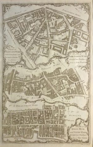
Plans of Aldgate, Lime Street, Queen Hith & Vicinity Wards
Dated: 1784Image Dimensions: 8½" x 13¼" (21.6cm x 33.7cm) -

Walbrook Ward and Dowgate Ward with their Divisions into Parishes
Dated: 1755Image Dimensions: 14½" x 9½" (36.8cm x 24.1cm)